
|
Old Testament
New Testament
Gospels
Acts
Paul's Letters
General Letters
Revelation
Topical Studies
Beginning the Journey (for new Christians). en Español

|
Old Testament
New Testament
Gospels
Acts
Paul's Letters
General Letters
Revelation
Topical Studies

|
Home
Bible Studies
Articles
Books
Podcasts
Search
Menu
Donate
About Us
Contact Us
FAQ
Sitemap


The route of the Exodus has been hotly debated. Since there are no archaeological artifacts from the Exodus itself and place names seldom match places identifiable today, we are left to sort out the probable route based on clues from the biblical accounts and the land itself. Three main routes of the Exodus to Mt. Sinai have been proposed.
1. Northern Sinai Route
The Northern Route sees the "Reed Sea" as Lake Serbonis, then along the Mediterranean coast of Sinai. It finds Mount Sinai in the northern part of the Sinai Peninsula. However, this route was heavily fortified by the Egyptians, since it constituted the route enemies would take to attack Egypt. This route is explicitly excluded by the text:
"When Pharaoh let the people go, God did not lead them on the road through the Philistine country, though that was shorter. For God said, 'If they face war, they might change their minds and return to Egypt.' So God led the people around by the desert road toward the Red Sea." (Exodus 13:17-18)
Moreover, the present Lake Serbonis probably didn't yet exist at the time of Moses.
2. Central Sinai Route
A route directly east of the end of Wadi Tumilat across the center of the Sinai Peninsula doesn't have enough wells to support this body of people and animals.
I've recently seen a variation on this -- not held by any reputable scholar -- that claims the "real" Red Sea ("Reed Sea") is the Gulf of Aqaba, the "real" Mt. Sinai is Jebel el Lawz in Arabia. The theory holds that Pharaoh's chariots chased the Israelites across the center of the Sinai Peninsula, then down the steep canyon of Wadi Watir, across Nuweiba beach, and a slightly submerged land bridge into Arabia.1 The problem with this view is that the Scripture shows the confrontation between Pharaoh and Moses at the Red Sea before the trek across the Sinai Peninsula, not after it. It just doesn't fit the facts of Scripture.
3. Southern Sinai Route (Traditional)
Below is a map that shows the traditional route that makes the most sense to me.
|
|

The traditional route crosses the "Reed Sea" at perhaps Lake Timsah or the Bitter Lakes, then down Sinai's west coastlands, then east through the mountains and wadis to a southern Mount Sinai, perhaps Jebel Musa, then back up northeastward by Sinai's east coast and desert to Kadesh-barnea. This route has the advantage that it:
- Steers clear of nearly all Egyptian presence.
- The Shur desert was also called the desert of Etham (Numbers 33:8), in the latitude of the east end of Wadi Tumilat. So, moving through that desert for three days (if the middle way of Seir is excluded) has to be southward along the west coast of Sinai.2
- The west coast of Sinai has a number of known watering places.
Of course, no one knows the route for sure. Very few of the stages of the journey outlined in Numbers 33 have been identified with any certainty, with the exception of Ezion Geber, Kadesh Barnea, and the plains of Moab.
Nevertheless, let's discuss some of the locations that we're more sure about -- plus a couple of others.
Ramses, Pithom, and Succoth (Exodus 12:37)
The locations of both Ramses and Succoth have been fairly well established. Scholars identify Rameses ("house of Rameses") as Qantir or Tell el-Dab`a, the ancient Avaris/Pi-Ramesse.3 It was originally built on the eastern bank of the Pelusiac, the easternmost of the Nile's five ancient branches. Later, prior to 1069 BC, the course this branch of the Nile migrated away from the city, and the site was abandoned.
Succoth4 (the modern Tell el-Maskhuta) is found in the Wadi Tumilat of the southeast delta.5 The name Succoth in Hebrew means "temporary shelters, tents, booths," which corresponds to the Egyptian name Tjeku.
Kitchen makes a strong case to identify Pithom ("house of the god Atum") as Tell er-Retabe along the Wadi Tumilat, a few miles due west of Succoth.6
Location of the Red Sea or yām sûp
We just don't know the exact location of the body of water identified in the text as the "Red Sea." The Hebrew is yām sûp, a term used in the Old Testament to identify a number of different bodies of water. Yām is used in the Old Testament over 300 times to refer to "sea" and about 70 times for "west" or "westward."7 The word sûp means "reed, waterplant," a general term for marsh plants.8 What we know as the Red Sea today lies to the south, with two northern branches, the Gulf of Aqabah to the east of the Sinai Peninsula and the Gulf of Suez to the west of the Sinai Peninsula.
According to 1 Kings 9:26 and other passages,9 the term yām sûp is used to describe Gulf of Aqabah (Elat), the body of water east of the Sinai Peninsula. Of course, in many many passages, yām sûp is the sea of the Exodus.10
|
|
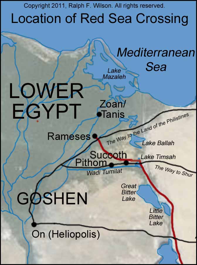
We conclude, then, that the "Red Sea" (yām sûp) refers to some body of water east of the Nile delta. Scholars have found evidence of ancient canals in this area. Here are the primary possibilities of bodies of water we see today along the line of the present-day 101-mile Suez Canal, which opened in 1869. North to south, these are:
- Lake Ballah
- Lake Timsah
- Great Bitter Lake
- Little Bitter Lake
Water tables, no doubt, are different now than they were 3,000 years ago, so we can't judge just by what we see today. Some believe that the Gulf of Suez gradually receded over the centuries, its coastline slowly moving farther and farther southward away from Lake Timsah and the Greater Bitter Lake to its present coastline today.11 "It is plausible, even if they were marshy areas, that the Israelites crossed while the area was flooded, which occurred periodically."12 The exact spot of the crossing is impossible to determine with certainty, but it probably occurred either at Lake Timsah or at the Great Bitter Lake.
The Sinai Coast
If, indeed, the Israelites took the traditional southern route, it would have been a difficult trip. Beno Rothenberg notes:
"Sinai's broad southern littoral [area near the shoreline] is for the most part a sandy waste. In the wadi-estuaries and in a few depressions between the sea and the mountains of Sinai the yellow sand is relieved by white patches of chalk and limestone, sometimes mingled with loess. In such parts there is water and vegetation: tamarisks, date-palms, and acacias. But the parched soil shrivels and crumples up in the fierce desert heat."13
Marah (Exodus 15:23)
Marah has been traditionally identified with Ain Hawara, but there can be no certainty. Beno Rothenberg observed in 1957 that Ain Hawara is "a spring now completely buried in sand. Only a cluster of date-palms and a damp spot nearby are there to tell of its existence."14
Elim (Exodus 15:27)
It has always been tempting for scholars to try to locate the oasis of Elim.
"Then they came to Elim, where there were twelve springs and seventy palm trees, and they camped there near the water." (Exodus 15:27)
Elim (ʾ�lim) is the plural of ʾayil, "terebinth, great tree," so Elim means "(place of) great trees."15 Some scholars identify Elim with the modern day Wadi Gharandel, located on the west coast of the Sinai Peninsula and the site of numerous palm trees,16 but it is by no means proven.
Mount Sinai
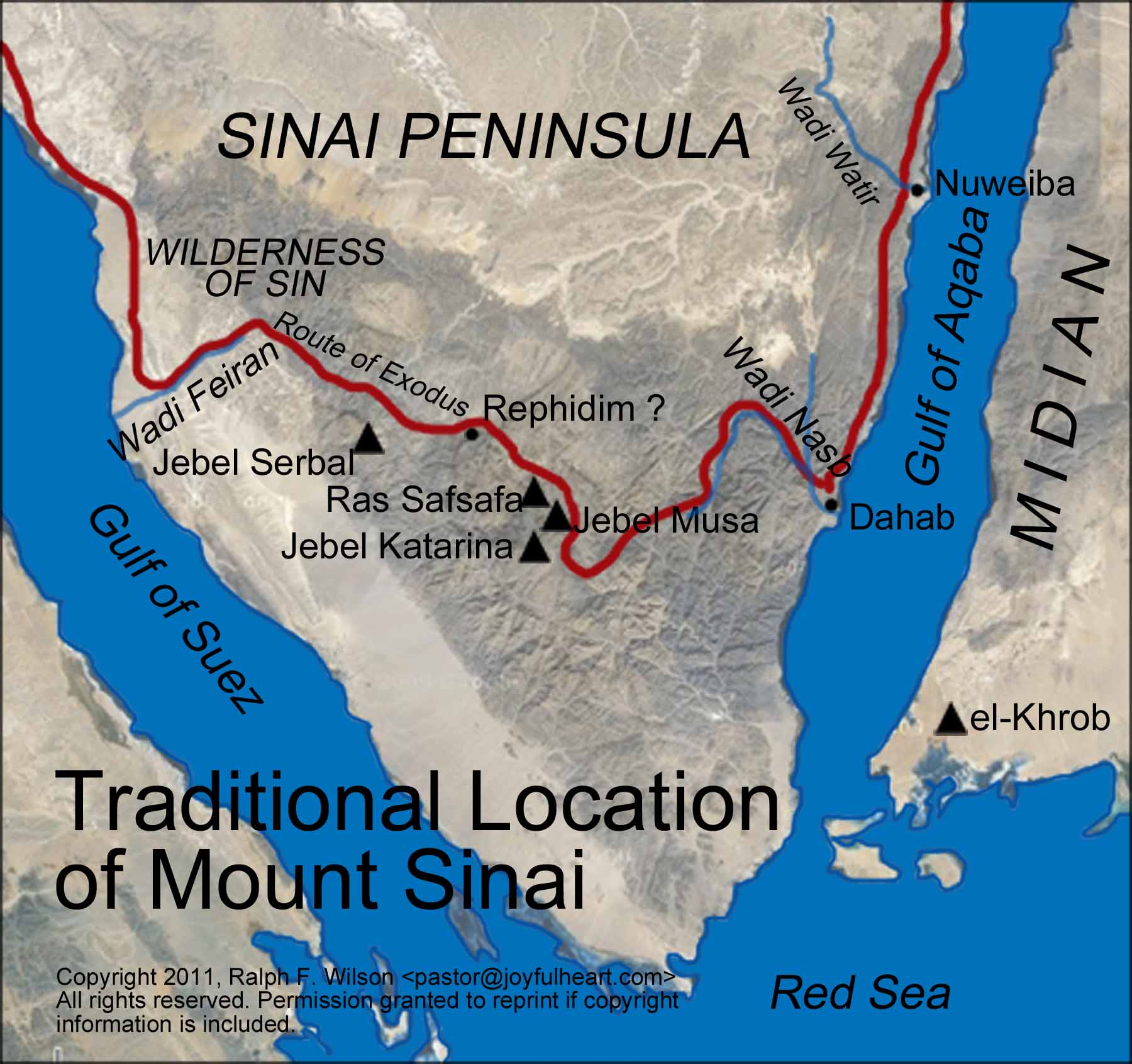 Possible locations of Mount Sinai in the southern Sinai Peninsula.18 Larger image. |
The exact location of Mount Sinai (sometimes referred to as Mount Horeb) is unknown. There are three theories as to its general location:
- Northern Sinai. Candidates suggested are Jebel Helal, Jebel Kharif, Jebel Sin Bisher, Jebel Yeleq, Jebel Magharah, Jebel Karkom, or Kadesh-barnea itself.
- Arabia. Mountains suggested are present-day Petra, el-Khrob, or Hala el-Bedr. This has a long tradition, but is unlikely.17
- Southern Sinai. The traditional southern route of the Exodus suggests four possible peaks, which I think are most likely, all clustered together: Jebel Musa ("Mountain of Moses") is 7,498 feet in elevation, Jebel Katarina is 8,551 feet, and Ras Safsafa is 7,113 feet. Jebel Serbal (6,739 feet) is west a few miles, near the Monastery of St. Catherine. Which of these peaks is the real Mount Sinai, God only knows, but each has its proponents.19
The location of Rephidim is unknown. However, many have placed it near the Oasis of Feiran. Yohanan Aharoni comments:
"Wadi Feiran is one of the largest and most famous wadis in Sinai. It is 81 miles long and begins in the region of Jebel Musa, where it is called Wadi el Sheikh. Feiran boasts the chief oasis in Sinai, one of the wonders of the Peninsula. In the heart of the bleak and forbidding granite mountains a green parkland suddenly comes into view: over 6 miles of date-palm groves, tamarisks, reeds, rushes, and other vegetation, with a small sparkling stream to delight the eye, artesian wells, and even a petrol engine to draw up the water. The inhabitants are Bedouin."20
Kadesh-Barnea
Kadesh is almost certainly to be identified with Ain el-Qudeirat in the Wadi el-Ain of the northern Sinai. "The vegetation near Ain el-Qudeirat and its ample supply of water suit very well the topographical requirements of the wilderness narratives."21 Ain el-Qudeirat is the richest spring in the Sinai, having a flow of about 40 cubic meters per hour.22
Mount Hor
The actual location of Mount Hor is unknown, but was considered in Edomite territory. Josephus identified Mount Edom as Jebel Nebi Harim near Petra. But a more likely location might be Jebel Madura, about 15 miles northeast of Kadesh at the edge of Edom's territory.23
Ezion-geber (Numbers 33:35; Deuteronomy 2:8)
Ezion-geber is almost surely located at Tell el-Kheleifeh at the north end of the Gulf of Aqaba.
Dizahab (Deuteronomy 1:1)
Dizahab must surely be related to the present town of Dahab, as both names are phonetic equivalents and both have to do with places of gold.24
 Available as an e-book and paperback |
Jotbathah (Numbers 33:33)
Jotbathah is quite likely to be the oasis of Taba, located about seven miles south of Ezion-geber on the eastern side of the Sinai Peninsula.25
Of course there are many speculations as to other identifications, but these are the most likely.
References
1. This view is "explained" in a series of slides on the Grace upon Grace Ministries website.� http://graceupongraceministries.org/video-feed� It is explained by Russell and Colin Standish, Holy Relics or Revelation (Rapidan, VA: Hartland Publications).
2. This analysis draws heavily on K.A. Kitchen, On the Reliability of the New Testament (Eerdmans, 2003), pp. 265-274. See also Peter Enns, "Exodus Route and Wilderness Itinerary," DOTP, pp. 272-280.
3. P. Enns, "Exodus Route and Wilderness Itinerary," DOTP pp. 272-280, especially p. 273.
4. Exodus 12:37; 13:20; Numbers 33:5-6
5. W.L. Thompson, Jr., "Succoth," ISBE 4:648); Kitchen, Reliability, pp. 256-259.
6. Kitchen, Reliability, pp. 256-259. J.H. Walton, "Exodus, Date of," DOTP, p. 262.
7. Paul R. Gilchrist, yām, TWOT #871a.
8. R.D. Patterson, sûp, TWOT #1479. Exodus 2:3, 5; Isaiah 19:6; Jonah 2:5.
9. Also Exodus 23:31; Numbers 14:25; 21:4; Deuteronomy 1:40; 2:1; Judges 11:16; Jeremiah 49:21.
10. Exodus 15:4, 22; Joshua 2:10; 4:23; Psalm 106:7, 9, 22.
11. "Suez Canal," Wikipedia, 12 Dec 2010, citing Édouard Naville, "Map of the Wadi Tumilat" (plate image), in The Store-City of Pithom and the Route of the Exodus (London: Trubner and Company, 1885); S Rappoport, History of Egypt (London, Grolier Society, undated, early 20th century), Volume 12, Part B, Chapter V: "The Waterways of Egypt," pages 248-257.
12. P. Enns, "Exodus Route and Wilderness Journey," DOTP, p. 276.
13. Ben Rothenberg, God's Wilderness, p. 93, plate 30.
14. Ben Rothenberg, God's Wilderness, p. 94, plate 33.
15. ʾAyil, BDB 18.
16. Kitchen, Reliability, p. 269, who sees it "possible, but not proven."
17. Arguments pro and con are presented in Beitzel, Atlas, pp. 90-91.
18. Map relies on Beitzel, Atlas, pp. 86-87, map 25.
19. Kitchen (Reliability, p. 270) says, "In practical terms, the immediate conjunction of clear space plus impressive mountain at Gebel Musa suits the biblical narrative much better than does Gebel Serbal.... Certainty is not attainable, but Gebel Musa may lead Gebel Serbal by a short head."
20. Yohanan Aharoni in God's Wilderness, pp. 135-136.
21. R.K. Harrison, "Kadesh," ISBE 3:1-2
22. Moshe Dothan, "The Fortress at Kadesh-Barnea," Israel Exploration Journal, 1965, pp. 134-51. A number of photos of Kadesh-barnea can be found in God's Wilderness, plates 10-17.
23. Harrison, Numbers, p. 272.
24. Beitzel, Atlas, p. 92 and Map 25.
25. Beitzel, Atlas, p. 92 and Map 25.
Copyright © 2026, Ralph F. Wilson. <pastor![]() joyfulheart.com> All rights reserved. A single copy of this article is free. Do not put this on a website. See legal, copyright, and reprint information.
joyfulheart.com> All rights reserved. A single copy of this article is free. Do not put this on a website. See legal, copyright, and reprint information.
 To be notified about future articles, stories, and Bible studies, why don't you subscribe to our free newsletter, The Joyful Heart, by placing your e-mail address in the box below. We respect your